
Interpreting the brief
The brief for the assignment was largely unchanged from the ideas created in Exercise 4.6 which were “to research and photograph Jacobean doocots (dovecots) in the East Lothian district. The project will be guided by the doocots listed in the 1937 publication ‘Transactions of East Lothian Antiquarian and Field naturalists Society Vol 3’ which listed the doocots and their state at that point in time. “
I chose to expand the aims as follows:
- Lost History and lost landscape due to the perception that Agri-rural history not being important enough to protect.
- An examination of the concept of a space becoming a place and what happens when there is a change of place.
- Examination the concept of land ownership in Scotland which is at times in conflict with the Scottish law of “Right to Roam”. This extends to the ownership and stewardship of historical buildings by the landowners
- Examination the idea of accessibility for all, by looking into how actual accessibility and disabled rights translate into walking on public land.
The main Influences for the project is the New Topographics group. I chose to approach the subject of landscape photography in a nonstandard way, which allowed me to concentrate on the buildings themselves as they stand within the context of the landscape rather than the other way around. The project is directly influenced by the work of Hilda and Bernd Becher and Edward Burtynsky. My aim was to produce a set of images within this aesthetic to show that the idea of landscape photography can be malleable.
Undertaking the Brief
The first challenge of the brief was to gather the locations as described in the original survey. The publication which was produced in 1937 is based on a survey of Jacobean Doocots undertaken in 1931 by J. Whitaker. The survey was never completed due to the untimely death of Mr Whitaker in 1932. The final survey was gathered from his notes and has additions from several individuals within the society who had worked with Mr Whitaker in compiling the information. The locations in the published survey differ from modern-day locations in several aspects. First, the publications use place names which in some cases are no longer in use. Second, due to the change in the shape of towns over 80 years, some of the places no longer exist. Thirdly, due to the nature of the buildings, some had already been lost by the time of publication. Land ownership has changed in the region from just a few central landowners who owned large tracts of land within their estate to a large number of smaller private owners of small parcels of land which is some cases are formerly estate land. Where there were small farms who worked small fields, there is now large industrial-scale farming which was knocked down many of the walls and boundaries and who have opened up the land, by removing the smaller older farm buildings, so that they can use large modern farming techniques and machinery.
Initially, my aim was to gather a basic survey and plot using digital maps, GPS positions and digital footprints from modern maps, alongside historical and archaeological websites. This was only partially successful as parts of the digital footprint were, in fact, direct text copies from the 1931 survey. In other cases, the data had not been revisited since the 1980s and was out of date. It quickly became clear that accessibility was an issue. At times, it required gaining permission from the landowner, and some requests were not well received. I had to deal with a number of landowners who were not aware of the Scottish right of way. In other cases, it was quite simply, that the stewardship of the land, the access path to the building and the building itself had not been undertaken and that the land was being left to be as unwelcoming and inaccessible, possibly with the aim of having the public right of way denied as it was no longer in use. In the majority of cases, no consideration was given for ease of access for the disabled.
When visiting the sites to capture my images, my main hurdle was in trying to give each location the same treatment. I quickly found that I could not use the treatment of a set distance using the same parameters – angle, height, position relevant to the camera in an attempt to capture scenes which will be comparable with each other. At several sites, I was forced to use a telephoto lens to photograph the subject as access was impossible. The project was further hindered when during a return from one site, I suffered a major muscle spasm and I dropped all my equipment breaking camera and lenses. I had to buy a new camera and lenses which were significantly different from the originals, and so a period of adjustment was required.
I took several photographs at each location, from varying distances, angles and positions. I then chose images which were not always identical, not because the subject matter was too similar or boring but because each subject photographed differently from the same position. Sometimes I felt that shadow or highlight distracted from the subject and so these images were discarded from the final choice selection. I felt that the basic shape of the doocot remained the same which allowed the topographic aesthetic to continue.
Outcome
I acknowledge that the potential outcome of a new Topographics style set of images was in danger of being abandoned as the images were at times completely different. I continued because I felt that the project was still probable. Even though I had to modify my set of rules, I continued to photograph as close as possible to those rules. The project gained in the weight of the brief regarding the accessibility/landownership aspect of the brief. After examining the first sets of images again, the topographic idea was strengthened. I could see the differences and the commonalities within the doocots and started to understand how and why they were there.
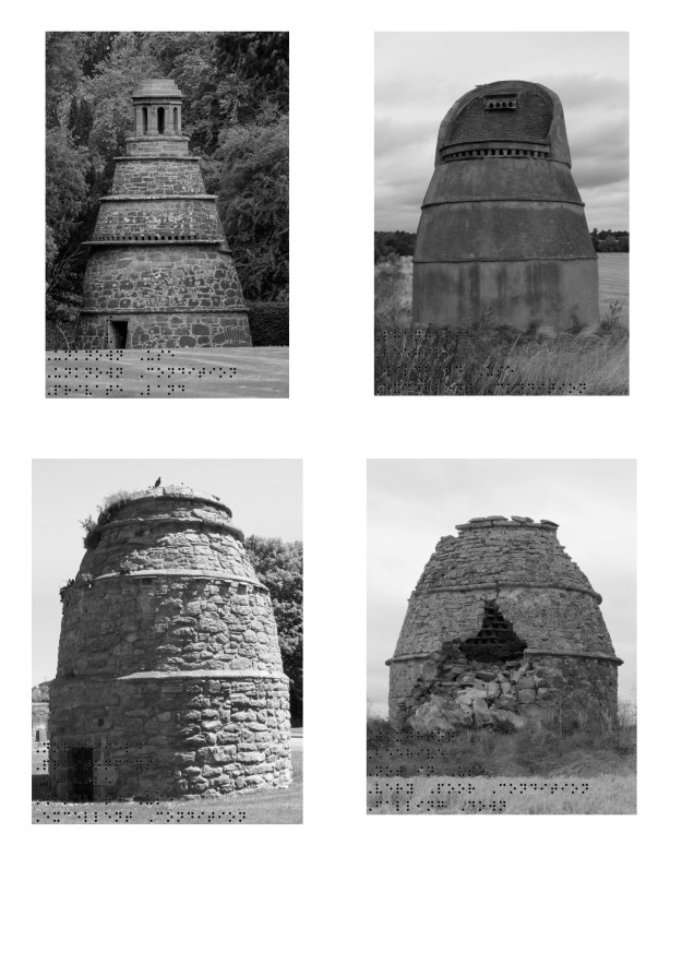
I broke the subject matter down into three distinct build types of the Jacobean period; the initial beehive shape, the later Lectern shape and the final tower shape. After this final shape doocots fell out of use. I used these shapes as the identifiers for their topographical type, trying to keep within a strict Linnaean definition of type.
Here the project will take two different routes:
Exhibition – The works will remain in colour and be printed individually on A4 and hung in alphabetical order, as per the original survey publication. This will be done to allow the viewer a chance to observe the differing archetypes of doocots and their current state against what was written about them in 1931.
Assignment and Final Submission – The works will be gathered together in a format similar to the Typographic aesthetic, with the doocots ranked first by type and then within that subset alphabetically. They will be presented in monochrome, as I found that the use of colour caused the images to be far too busy and the subject matter was overshadowed by the colour. In some cases, nothing could be seen of the final sets of images but washes of green and brown.
As with Assignment 3, I have continued with the exploration of visual accessibility by placing braille in the images. Again, I have kept the braille to a minimum size, as it represents my own partial loss of vision and the continued disturbance it contributes to what I see. I decided with black braille this time, as I wanted the normally sighted viewer to understand that for some people with vision loss, that this is an invisible disability and so, is unseen, and like the braille, not understood by the main populace.
Beehive
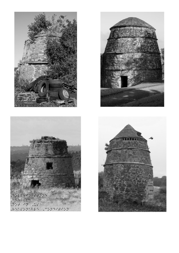
Congalton/Dirleton/Dolphingston/Drylawhill
Nunraw/Phantasse/Preston Mains/Waughton
Lectern

Athelstaneford/Belton/Bourhouse/Crocegate

East Fortune/Friars Croft/Hermanston/Humbie

Johnstounburn/Lady Kittys/Nungate/Pencaitland

Preston Tower/Redhouse/Saltcoats/Spott

Tantallon/Tranent
Tower

Amisfield/Bolton/Colstoun/Elvingston

Haddington/Heugh/Lodge/Newton Hall
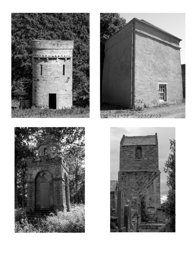
Ormiston/Prestongrange/Saltoun/Stenton Church
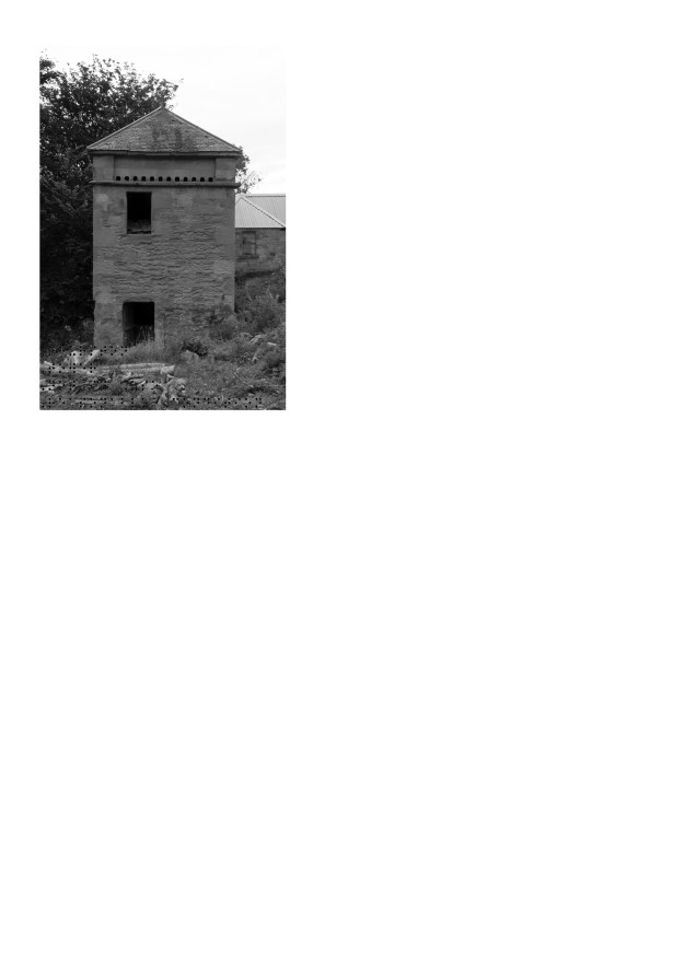
Thurston
Torn Done
The black and white shapes represent the unknown effect of losing doocots. The red ‘X’ is representative of the more computer-driven iconography of a missing image link, usually presented through an internet browser.

Inaccessible
This was created to represent the hostility felt when approaching landowners when attempting to gain access to their land to locate and photograph a piece of local history.

Conclusion
Do I consider these images as landscape? Yes, I do. These doocots represent a space which was by kings statute created on the land as a representation of the Lairds fealty to King James VI and the money and the power that they held over their tenants. These spaces have in fact become places, lending of their name to locations, such as dovecot farm, or dovecot lane, even where the doocot has been destroyed. These images represent the land as pieces of history, some of which have already been lost and some of which are inaccessible due to the fencing in of property by later landowners.
By bending the Topographic rules which I had set in the brief, I have created a set of images which are not repeated regular architectural shapes. Each location shows its own individuality through its setting and the final image selected. Some of this is down to the different time of day, differing light conditions and differing lenses but also down to the location itself as each site had its own set of identifying features even amongst the most common of buildings.
The work took longer than designed into the original brief, due to the amount of research required to locate the physical doocots. Since the survey was never fully completed, I had to pick up where it left off and continue to locate the doocots and acquire access. This was not always easy as a disabled person and a person with visual impairment. I also had to manage the issues of surrounding my health condition, and my energy levels. I was not always successful in getting these to align and ensure that I was able to get out and photograph when the weather allowed it.
I am satisfied with the final work as it covers the points I wanted to raise within the brief
- Local history some of which is being lost
- Social Inclusivity of the landscape
- Power, stewardship and ownership of the Landscape
All of these points are covered in the completed work both in exhibition form and in the submitted form.
Once the project is completed, I hope to offer Historic Scotland a number of images for their Canmore site. This will allow Canmore to update their database with the missing images and information about the current condition of the Doocots. These records could then be made accessible for the public and could also be available for reference through the East Lothian Council’s John Gray Research library and website.
References
British Journal of Photography. 2019. Edward Burtynsky: The Anthropocene Project – British Journal of Photography. [ONLINE] Available at: https://www.bjp-online.com/2018/10/edward-burtynsky-the-anthropocene-project/. [Accessed 10 October 2019].
Welcome to Canmore | Canmore. 2019. Welcome to Canmore | Canmore. [ONLINE] Available at: https://canmore.org.uk/. [Accessed 4 April 2019].
Dovecotes of Old England, Wales and Scotland. 2019. Dovecotes of Old England, Wales and Scotland. [ONLINE] Available at: https://www.pigeoncote.com/dovecote/dovecote.html. [Accessed 10 October 2019].
East Lothian Antiquarian Society. 1938. East Lothian Antiquarian Society. [ONLINE] Available at: https://eastlothianantiquarians.org.uk/files/2018/02/1934-38-ELAFN-Soc-Transactions-Vol-III.pdf. [Accessed 26 September 2019].
Edward Burtynsky. 2019. Edward Burtynsky. [ONLINE] Available at: https://www.edwardburtynsky.com/. [Accessed 12 June 2019].
Historic Environment Scotland | Àrainneachd Eachdraidheil Alba. 2019. Historic Environment Scotland | Àrainneachd Eachdraidheil Alba. [ONLINE] Available at: https://www.historicenvironment.scot/. [Accessed 1 October 2019].
John Gray Centre. 2019. Haddington Library – John Gray Centre. [ONLINE] Available at: https://www.johngraycentre.org/about/library/. [Accessed 10 October 2019].
New Topographics: “Landscape and the West – Irony and Critique in New Topographic Photography” (2005) – AMERICAN SUBURB X. 2019. New Topographics: “Landscape and the West – Irony and Critique in New Topographic Photography” (2005) – AMERICAN SUBURB X. [ONLINE] Available at: https://americansuburbx.com/2012/05/new-topographics-landscape-and-the-west-irony-and-critique-in-new-topographic-photography-2005.html. [Accessed 15 June 2019].
New Topographics: Photographs of a Man-Altered Landscape …. 2019. New Topographics: Photographs of a Man-Altered Landscape …. [ONLINE] Available at: https://www.sfmoma.org/exhibition/new-topographics/?ds_rl=1263130&gclid=Cj0KCQjwrfvsBRD7ARIsAKuDvMN-Y5AzdamX3TGr-T1gX3l8aRTxOcphHJCNTWPtMRHyzUPbxrRkgKQaAoRCEALw_wcB. [Accessed 16 June 2019].
Ogilvie Homes. 2019. Dovecote Steadings, East Lothian – Ogilvie Homes. [ONLINE] Available at: https://www.ogilviehomes.co.uk/location/dovecote-steadings-east-lothian/. [Accessed 10 October 2019].
Preston Mill & Phantassie Doocot, East Linton – Historic Buildings & Homes | VisitScotland. 2019. Preston Mill & Phantassie Doocot, East Linton – Historic Buildings & Homes | VisitScotland. [ONLINE] Available at: https://www.visitscotland.com/info/see-do/preston-mill-phantassie-doocot-p255601. [Accessed 8 October 2019].
Showcase Archives. 2019. East Lothian Antiquarian And Field Naturalist Society. [ONLINE] Available at: https://demo.orangeleaf.com/collections/getrecord/ELCAS_EL335. [Accessed 7 October 2019].
Tate. 2019. New topographics – Art Term | Tate. [ONLINE] Available at: https://www.tate.org.uk/art/art-terms/n/new-topographics. [Accessed 16 June 2019].
Tate. 2019. The Purloined Landscape: Photography and Power in the American West – Tate Papers | Tate. [ONLINE] Available at: https://www.tate.org.uk/research/publications/tate-papers/21/the-purloined-landscape-photography-and-power-in-the-american-west. [Accessed 15 June 2019].
Tate. 2019. Who are Hilla and Bernd Becher? | Tate. [ONLINE] Available at: https://www.tate.org.uk/art/artists/bernd-becher-and-hilla-becher-718/who-are-bechers. [Accessed 16 June 2019]
